

Today with virtually every person having a smartphone, it has become a lot easier to find your way, as these devices come equipped with a GPS system that helps in finding a way for travelers. And in modern times when people are constantly on the move from one place to another, these indoor navigation apps come around as a blessing for them. GPS technology is great for outdoor, but when it comes to finding your way indoors, like in crowded shopping centers, cafes, shops, restaurants, traditional markets, or shops inside large complexes, somehow a traditional GPS-based mapping app fails to perform.
Hence, for the indoors, you need special indoor navigation and positioning apps that are different from the outdoor navigation apps. The thing is the GPS outdoor navigation apps use GPS satellite signals and they usually lose signal when in crowded places or inside large complexes or buildings. Whereas, these indoor positioning apps are specifically created for smaller areas where they work with augmented reality displaying your location just by simply accessing integrated GPS maps. When the user accesses the inbuilt GPS maps available in the apps, they offer the shortest possible routes towards your destination.
Market Statistics for Indoor Positioning Apps
As per the statistics, in the year 2017, the worldwide Indoor Positioning & Navigation market was valued at $6.92 billion, and it is estimated to grow to $23.6 billion in the year 2023. In fact, the United States is the major market for these apps and it accounts for a 40 percent share in the global market.
- The worldwide market for indoor location, in terms of revenue, reached approximately $8.8 billion, and it is expected to reach a revenue of about $24.0 billion by the end of 2027, with a projected CAGR of 22.4% from 2022 to 2027.
And in case, you are someone looking to build an Indoor Navigation app, then you are at the right place. So, first, let’s begin by understanding what is an Indoor Navigation system?
What Is Indoor Positioning & Navigation App?
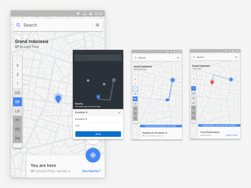
Same as the outdoor GPS Navigation apps, the indoor navigation apps allow users to find an exact location within large commercial spaces. It is the latest way as it comes to the world of wayfinding. These IPS-enabled services help in quickly locating the spaces inside airports, hospitals, and other locations. It shows the users standing positions on the maps and it directs them to the shortest path so they can quickly reach their destination.
And in order to offer superb performance, this indoor navigation system requires:
- Smartphone with IPS app installed
- BLE Beacons that guide the users from source and destination
- The app requires a destination facility map
- Back-end servers to calculate an indoor destination
How These Indoor Navigation Apps Are Useful?
Mainly, these apps focus on navigation, positioning, and sending notifications to the users’ mobile that helps the users to easily reach the desired destination. They help individuals and businesses in a number of ways and allow the users to navigate quickly in fully crowded and large shopping spaces and airports. The indoor navigation apps are very useful for the visitors as they do not require asking people or browsing google as everything becomes smart with these apps and they can reach their destinations quickly without any difficulties. Just use your smartphone to simply download the app and reach your destination in no time, and all that you need is:
- Get facility map online
- Search for the desired venue
- View the shortest possible route
- Voice assistance is provided to reach the destination
Essential Features of an Indoor GPS App
When developing an indoor navigation app, there are several key features you may want to consider including. Here are some main features to include in your app:
| Feature | Description |
|---|---|
| Map Creation | Users can create digital maps of indoor spaces or upload existing floor plans. |
| Location Tracking | Real-time tracking of users’ positions within the indoor environment using Wi-Fi, Bluetooth, or beacons. |
| Routing and Directions | Step-by-step directions from the user’s current location to their desired destination, considering shortest paths. |
| Search Functionality | Users can easily search for specific locations or places within the indoor space. |
| Points of Interest | Highlighting important spots like restrooms, elevators, entrances, or specific stores on the map. |
| Floor Selection | Users can choose different floors in buildings with multiple levels. |
| Augmented Reality | Overlapping navigational information on the camera view for a more intuitive experience. |
| Notifications/Alerts | Sending alerts and notifications for upcoming turns, important information, or announcements during navigation. |
| Accessibility Features | Features to assist users with disabilities, such as audio instructions, visual cues, or wheelchair-friendly routes. |
| Integration with Other Services | Connecting with transportation or event management apps for additional services and convenience. |
Advantages Of Indoor Navigation Software Applications Are:
- Reliable
- Economical
- High-precision
- Pointing the way
- Maintenance-free
- Offline Capability
- Easily integrated into an app and software environment
- Barrier-free for the blind and visually impaired people

Top Indoor Navigation Mobile Apps
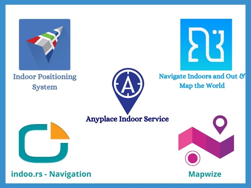
Indoor positioning system, Anyplace Indoor Service, indoo.rs – Navigation, Navin, Mapwize are some of the mobile apps and software that are built for navigating indoors.
How Indoor Navigation Apps Can Be Beneficial For Businesses?
When businesses utilize this service in the best possible manner by putting it for good use and adding great convenience to users, they can tremendously benefit from this service. The idea here is the app be beneficial for both the visitors and the facility owners, as it allows them to locate places and things inside large complexes where the GPS signals just don’t work.
For instance, there is Path Guide, which happens to be the most leading indoor positioning & navigation apps and the users are greatly impressed with its design and functionality. And in case you want to create an app just like Path Guide, then you need to understand that such apps are based on Augmented Reality technology that helps in creating detailed Indoor maps. The main functionality of these apps is positioning, navigating, and sending notifications. Let’s further understand its every purpose:
Positioning: Here the technology allows to find the exact position of any place inside large buildings, be it shopping complexes, camps, hospitals, or any person that is standing in parking.
Navigation: Here the technology is useful to find the shortest route and this helps the users in reaching their final destination quickly without any difficulties.
Push Notifications: This notifies the users regarding locations/places by just sending the notifications on the user’s mobile. Other than these functionalities, the Indoor Positioning apps offer huge benefits to the businesses, like:
Gather Data of Visitors: User Data is crucial for any business, and the Artificial Intelligence-integrated Indoor positioning apps help the users to collect visitors’ data and keep track of the number of visits, and the time spent in a specific place, and also how often these users visit their favorite places.
Send Notifications: By using and analyzing the visitors’ history, the businesses can easily generate trigger-based events and they can send notifications to the visitors often visiting that specific place. These apps can flag up the discounts, or pop-up notifications as the visitors go towards that particular place or as they pass through those stores.
How Do These Indoor Navigation Apps Work?
Usually, these indoor positioning systems leverage internal sensors of your smartphone for calculating indoor positioning of the devices by simply utilizing complex mathematical algorithms. Then, it combines incoming data that comes from sensors in a smart way for calculating accurate positioning of the device and avoiding any latency. In order to fetch and deliver accurate positioning results and a smooth user experience, this indoor navigation system needs to rely on three main elements, such as:
- Underlying dynamic positioning system platform
- Beacons broadcasting signals received from the smartphone
- Serving signals to the positioning system
These three main elements help to combine and collect the data from different resources and calculate the exact user position. Hence, mainly for the indoor navigation app to work well, it needs a unique set of functionalities that we will discuss ahead. But first, let’s understand the usefulness of the indoor navigation system.
Usefulness Of Indoor Navigation Apps For Businesses
Often it happens that the app development confuses the users, in terms of how that particular app can be used. However, this new era of technology has added value to applications and provides better services.
These indoor positioning apps are helpful and reliable as it comes to shopping complexes, airports, malls, railway stations covering larger surface areas. Also, this kind of advanced technology can even be leveraged by offices, hospitals, colleges, and warehouses, as it makes it easier for the users to find destinations with the shortest possible routes without any hassles. And as we speak of the idea behind these apps, they are mainly created for providing assistance in finding ways inside large complexes, buildings, as there the GPS (Global Positioning System) doesn’t work, and thus indoor navigation app is beneficial for smartphone users to reach their destinations.
Usefulness Of Indoor Positioning & Navigation Apps For Users
So, we have seen in so many ways the indoor navigation apps can be beneficial for businesses, and now let’s talk about how these apps can benefit the users.
In terms of users, the apps allow them to easily search the best and shortest possible routes inside the building in real-time as the technology allows easy navigation. With the help of apps, the entire search procedure gets easier as it consists of an option of Voice destination and allows them to create and find the shortest & easiest routes. And this is the main reason behind the making of these newly trending indoor mobile apps.
Who All Can Benefit From Artificial Intelligence Based Indoor Navigation Apps?
There are a lot of them who can benefit from these systems, like:
- Government Authorities for Transport
- Universities
- Hospital Owners
- Hotels & Resorts
- Offices & Property Management Companies
- Architects & Builders
- Shopping Mall Owners
- Stadium & Arena Management
- Walking Tour Guides
- National Library Management
- Museum Administration
- Theme Park Owners

Used Cases for Indoor Navigation
Indoor navigation apps can be utilized across various industries and sectors. Here are some industries where an indoor navigation app can be beneficial:
| Industry | |
|---|---|
| Retail | Help shoppers find stores or products in large shopping malls or retail outlets. |
| Healthcare | Assist patients, visitors, and staff in navigating hospitals, clinics, and medical facilities. |
| Transportation | Guide travelers in airports, train stations, and bus terminals to their destinations within the transportation hubs. |
| Hospitality | Aid guests in navigating hotels, resorts, and conference centers to find amenities and facilities. |
| Education | Assist students, faculty, and visitors in finding classrooms, libraries, and other facilities within educational campuses. |
| Museums/Galleries | Enhance visitor experiences in museums and galleries by providing guidance and information. |
| Corporate Offices | Help employees and visitors find offices, meeting rooms, and common areas within office buildings. |
| Exhibition Centers | Guide attendees at trade shows, conventions, or exhibitions to locate exhibitor booths and seminar rooms. |
| Entertainment Venues | Assist visitors in stadiums, arenas, or amusement parks to find seating, food areas, restrooms, or attractions. |
| Government Buildings | Aid citizens in navigating government offices or municipal buildings to access services or specific departments. |
What Technologies Are Used to Create an Indoor Navigation System?
There are a number of technologies used for Indoor Positioning System and here we discuss a few of them:
Global Positioning System (GPS)

This is the most commonly used technology in the navigation space, however, it fails to provide accurate navigation or positioning inside a building. It accurately works in large/low-rise buildings, such as airports, but fails to determine finer details, like floor number, and the only way to know that is doing it manually, just as one does in Google and Apple Maps. Hence, GPS is not a viable option for indoors.
Visual Positioning System
This is quite an advanced technology, for instance, there is Google that uses Street View data for clarifying a user’s position in the Augmented Reality-based outdoor navigation, as it uses the surrounding buildings as the reference points. Besides, ARKit2 brought ARWorldMap class that serves a similar purpose and it is mainly a set of feature points around a user, such as “the world’s fingerprint” that can be identified. However, one can’t totally depend solely on ARWorldMap for determining the exact location of Indoor Positioning as:
Often it happens that the offices look just the same in different places, like the rooms and the corridors might be identical on different floors and this is why it not possible to always succeed in visually determining the location. Like the interiors might change and this confuses the ARWorldMap and the complex calculations also make the solution pretty slow.
Beacon-Based Indoor Navigation
As it comes to Indoor Navigation, Beacon is yet another popular technology that is often used. An example of this is the use of 2000 battery-powered Bluetooth Low Energy beacons installed at the Gatwick airport, United States, giving +/-3m accuracy. However, as per Apple documentation, beacons just give approx. distance value and thus one can’t rely on signal strength as they try manually calculating this data. And as you consider the other factors, like cost ($10-$20/item), battery replacement once every one-two years, and working range (10-100 meters), then it gets clear that the usage of beacons for indoor navigation is only effective under certain conditions. However, beacons can do a nice job same as other current indoor positioning technologies available in the market which are beacon-based and using AR only for route visualization. However, it would be better to leverage ARKit & ARCore SDKs’ functionalities for solving the issue of user positioning.
Visual Markers
Also termed as AR Markers, or ARReferenceImage, Visual Marker is an image that is recognized by Apple’s ARKit and Google’s ARCore as well as other AR SDKs. These markers are used for telling the app where the AR content is best placed. So, when a visual marker is placed at some space, such as onto the wall or floor surface, and then its exact location is stored in the cloud, so while scanning, the app shows not only just place but its exact matches in the real world.
The visual marker technology can be used to a very accurate position with ARCore up to several millimeters. In terms of the accuracy levels, as usually everyone wants to know how accurate results these apps deliver, well then it can be said that the father the visual marker is from its starting point, the more inaccurate is the result. And to deal with this issue, one can place new visual markers on average every 50meters.

How To Create An AR-Based Indoor Positioning App?
So as you are looking to create an AR-based Indoor Navigation App for your business, it is a good strategy to get in touch with a good indoor positioning app development company in order to attain the desired results. And as one begins with the development process, it is good to ensure that the augmented reality company you choose for the development work has a team of the following experts:
- Project Manager
- iOS/Android developers with expertise and experience with ARKit/ARCore
- UX/UI Designers
- Back-end Developers
- Quality Analysts
Now let’s take a close look at each development stage:
Pre-Contract Stage
This is where the software firm can clarify their project requirements and the business needs of the clients, brainstorm the most efficient options and accordingly come up with a technical strategy. Here, the business analysts & project managers work together with the product owners & stakeholders for creating a consistent overall vision of the AR app, while keeping in mind all the project constraints (such as budget, deadlines, corporate environment, and technology). Also, the Technical Analysts provide an overview of available development tools, hence it is easier to decide on the technology stack.
Design Stage
This stage is about regular wireframing, sketching, mockups, mapping, 3D Object creation, and a lot more.
Development Stage
This stage consists of creating Proof of Concept (POC) for testing the idea and the result in minimum time. If needed, one can even create a hard-coded route and customized features, like voice recognition. For the development of an AR-based IPS app, one needs to go with Apple’s AR Kit or Google’s ARCore software development kits as per project requirements.
Step-by-Step Development of an Indoor Navigation App
Developing an indoor navigation app involves several steps to ensure a successful implementation. Here’s a overview of the steps involved in developing an indoor navigation app:
- Define Requirements: Clearly define the objectives, features, and functionalities of your app. Identify the target audience, supported platforms (iOS, Android, etc.), and the specific indoor environment you’ll be focusing on.
- Map Data Acquisition: Obtain the necessary map data for the indoor space you’re targeting. This can include floor plans, architectural drawings, or other relevant information.
- Positioning Technology Selection: Choose the appropriate positioning technology for indoor tracking, such as Wi-Fi, Bluetooth Low Energy (BLE), beacons, or a combination of these. Research and select the technology that suits your requirements.
- Data Preparation and Integration: Prepare the acquired map data and integrate it with the selected positioning technology. This step involves aligning the map data with the positioning system and ensuring accurate location mapping.
- User Interface Design: Design an intuitive and user-friendly interface for your app. Consider the map visualization, search functionality, route display, and any additional features you plan to include.
- Navigation Algorithm Development: Develop algorithms to calculate routes and provide navigation instructions. Consider factors like shortest path, accessibility, and any user preferences (e.g., avoiding stairs).
- Backend Development: Build the backend infrastructure to support the app, including server-side components, APIs, and data storage for map data, user profiles, and other relevant information.
- Frontend Development: Implement the app’s frontend components, including the map display, user interface elements, search functionality, and navigation features. This typically involves coding in the appropriate programming languages (e.g., Swift for iOS, Java/Kotlin for Android).
- Testing and Debugging: Thoroughly test the app to ensure accurate positioning, reliable navigation, and seamless functionality. Perform both unit testing and real-world testing within the target indoor environment.
- Deployment and Maintenance: Publish the app on the respective app stores (e.g., Apple App Store, Google Play Store) or deploy it through other distribution channels. Regularly maintain and update the app to address bugs, security issues, and feature enhancements.

How Much Does It Cost To Create An Indoor Navigation App Development?
Mainly the cost of creating an indoor positioning app depends on the business requirements with the app and a rough idea can be gathered depending on the features, functionalities, location of the development company, number of platforms for which the app is being developed, etc. In some cases, the development of an indoor navigation system can be an expensive affair when integrated with advanced features and technologies. However, calculating them all, the development of an average navigation app for indoors might cost around $25000-$30000, while the creation of a full-fledged app with all the advanced features and technology integrated into it, the app might cost somewhere around $50000-$60000.
However, after the development of the app, there are a few services for which the company has to pay, such as:
- Arbitrary Services
- BLE Beacons for channeling the push information and updates to customers
- Mobile Updates, as the indoor navigation apps need them to refrain from any issues.
- Cost to build a server, as servers stores the complete mapping knowledge with all the directions
- Paid Subscriptions for fetching a certain position or a place as well as for PaaS (platform-as-a-service)
Conclusion
Above we have covered all the crucial aspects of indoor navigation mobile apps and how they can be created for best use by the businesses and providing many benefits to the users. Hence, if you are looking to create such an app, simply get in touch with an indoor navigation app development company to fetch desired results.


 emizentech


